

Monitoring lithospheric motions by Satellite Geodesy
In this project we studied the lithospheric motion and the Earth’s mass change in terms of gravity variation, using a combination of geodetic satellite data and non-geodetic observations.
In this project we studied the lithospheric motion and the Earth’s mass change in terms of gravity variation, using a combination of geodetic satellite data and non-geodetic observations.
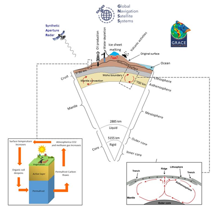
Understanding global and local Earth’s dynamic processes are important to the Earth’s system knowledge, human life, and sustainability goals (e.g. climatic change and geo-hazard assessment, etc.). The processes are largely affected by the Earth's mass distribution and redistribution, which can be quantified and modelled using simultaneous and complementary data from various geoscience and environmental near earth-orbiting artificial satellites. In this PhD project (funded partially by J. Gust. Richert foundation), we studied the lithospheric motion and the Earth’s mass change in terms of gravity variation, using a combination of geodetic satellite data and non-geodetic observations.
Mohammad Bagherbandi
Email: mohammad.bagherbandi@hig.se
Nureldin A.A. Gido
Email: nureldin.ahmed.adam.gido@lm.se
Faramarz Nilfouroushan
Email: faramarz.nilfouroushan@hig.se